#1 ShweDagon Pagoda
View More places for Yangon
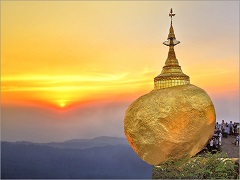
#2 Kyaiktiyo Pagoda
View More Places for Mon
#3 Mahar Myat Muni

View More Places for Mandalay
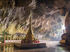
#4 Sadan Cave
View More Places for Karen State
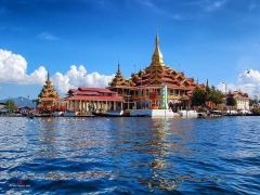
#5 Inle Lake
View More Places for Shan State
Locate Yangon
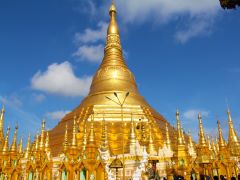
No visit to the Union of Myanmar is complete without a visit to the 2,500 years old Shwedagon Pagoda, which enshrines strands of Buddha's hair and other holy relics. Located west of the Royal Lake on 114 -acre Singuttara Hill in Yangon, Shwedagon Pagoda is the most sacred and impressive Buddhist site for the people of the Union of Myanmar. From a humble beginning of 8.2 meters, the Shwedagon Pagoda today stands close to 110 meters. Shwedagon Pagoda is covered with hundreds of gold plates and the top of the stupa is encrusted with 4531 diamonds; the largest of which is a 72 carat diamond. It is clearly one of the wonders of the religious world. Shwedagon Pagoda is a repository of the best in Myanmar heritage – architecture, sculpture and arts. The Shwedagon Pagoda consists hundreds colorful temples, stupas, and statues that reflects the architectural era spanning almost a 2,500 years. To understand this monumental work of art and architecture, visitors will experience an insider's view of this magnificent symbol of Buddhism to the lives of the Myanmar people. Shwedagon Pagoda forms the focus of religious as well as community activities – the bustling of devotees and monks washing the statues, offering flowers, worshiping, and meditating. Shwedagon Pagoda is administered by the Board of Trustees of Shwedagon Pagoda.
Locate Mon
The south eastern state of Mon is flanked on its western border by the Andaman Sea, by Bago to the north, Kayin to the east and Tanintharyi to the south. Mon State covers 12,296 km2, and consists of 10 townships and Mawlamyine is the capital city. The population is 2.12 million (2011 HMIS data), with a density of 172 people per square kilometre. 23% of the population live in urban areas, and the remaining 77% in rural areas.Mon state is sandwiched between Kayin (Karen) state on the east, the Andaman sea on the west, Bago division on the north and Thaninthayi division on the south. It has a short border with Thailand's Kanchanaburi province at its south-eastern tip. The topography is hills on the east, and coastline, beaches and islands on the west. Main rivers are the Thanlwin and its tributaries: the Gyaing, the Ataran and the Donthami. The Donthami form the border between Mon and Kayin state for a distance. The Ataran is one of the few rivers in Myanmar that flow south to north. The Ataran plain is wide and liable to floods. The state is located in the hot wet region. Similar to Thaninthari division, Mon state receives rains more months (June till November) than other parts of the country, with a thin cool season of a few months (normally December and January). The majority of the people are Mon; there are also Kayin, Shan, Pa-O, Bamar and others. Rice is the major crop of lowland areas, and lower slopes of the hills are used for rubber plantation and fruit trees. Rice, rubber, sugar cane, betal nut and coconut are major agricultural products. Fruits of Mon state include durian, mangosteen, pumalo. Around half of the land is covered with forests and timber production is one of the major economy. Fishing also plays a singnificant role in the economy of the state.
Locate Mandalay
Mandalay division is a large lowland area between the Ayeyarwaddy river on the west and the Shan hills on the east. The general elevation is around 150 meters above the sea, however the places on the east on the foot hills of Shan plateau and the southern part situated on the northern Bago range are much higher. Ayeyarwaddy river is the divisional border between Sagaing and Mandalay, as well as between Magwe and Mandalay. Mandalay and Magwe divisions, together with lower Sagaing division form the central low land dry zone of the country. In the lowland the weather is hot, and the dry season is long. The hottest month is April when the temperature could reach 40ºC at day time. The summer generally occurs in February till July. Then comes the rainy season from June to October. November to middle of February is the cool season. The temperature difference between day time and night time is larger in the central plain than in other parts of the country. However the north-eastern parts such as May Myo (now called Pyin Oo Lwin) and Mogok both are on the Shan hills are much cooler. The nights in January could be as cold as near zero. Rainfall is one of the lowest in the country. The central triangle bounded by Mandalay, Myingyan and Yamethin is the driest part. In the dry areas the vegetation is scrubs, bushes, thorn bushes, htanaung, tamarind, toddy plam and so on. Wetter and higher lands such as Pyinmana (in the south, on Bago range), and May Myo and Mogok have greener forests with both hard wood and soft wood trees.
Locate Karen
Kayin (or Karen) state occupies eastern part of the Thaninthayi (Tenasserim) mountain range, and is bordered with Thailand's Tak and Mae Hong Son provinces on the east. Northern and eastern parts of the state are mountainous, and the low land slopes are found in the south and south-western areas that border Mon state. The Thanlyin (Salween) river runs through the middle of the state. Kayin, Mon, Shan, Kayah, Bamar are the major groups of people living here. Main economy is agriculture and its related businesses. Rice, betelnut, ground nut, sesame, peas, beans, coffee, tea are grown. Rubber plantation are found in the southern areas. Evergreen forests cover roughly half of the region. Teak and other hard wood timber are important products of the region. Oppsoite Pha-An, on the western side the Thanlyin river there is a cement production plant in Myaing Ka Lay district. Some of the eastern parts bordering Thailand are under the control of armed groups that are said to have been fighting the government forces. There are news (2004) that these insurgent groups have been in talks with the government for cease fire agreement and possible cooperation on the country building.
Locate Shan State
Shan state is the largest province of Myanmar, bordering China's Yunnan province to the north and Thailand's Mae Hong Son, Chiang Mai and Chiang Rai provinces to the east. The physical nature is plateau and succession of mountain ranges said to be older than those in the western regions of the country. There are many river streams; the largest and longest being the Thanlwin (Salween) which enters Shan state from Yunnan province and flows north to south and later goes through Kayah, Kayin and Mon states before draining into the Andaman sea. The Mekong river serves as border line between China and Shan state for a short 40km at the eastern tip, and again between Laos (Luang Nam Tha and Bokeo provinces) and Shan state before arriving at the famous golden triangle tip where Laos, Myanmar and Thailand meet. The average height of the plateau is 900 meters. The plateau rises quite abruptly from the central plain. Many ethnic tribes live in the state, including Shan, Intha (poeople who live on the Inle lake), Danu, Taungyoe, Pa-O, Musay, Akha, Palaung, Lisu, Wa, Bamar and Thai.